A Rhododendron Expedition to Sulawesi, Indonesia
Henry R. (Hank) Helm
Bainbridge Island, Washington
John Farbarik
Silverdale, Washington
There are many reasons why people travel to different parts of the world, not the least of which are adventure and the rare opportunity to search for and to see vireya rhododendrons in the wild. The trip to the island of Sulawesi, Indonesia, was made for both of these reasons.
This expedition was unique in several ways. Neither John nor Hank were experts in the field of vireya rhododendrons. John had only a passing acquaintance with these plants and Hank little more, having done limited research on the section
Vireya
. John was familiar with Sulawesi and knew some Indonesian, while Hank had never been to Indonesia and knew no Indonesian. Neither John nor Hank had previously climbed to elevations exceeding 6,500 ft. (1,980m).
John had made a previous trip to Sulawesi in the spring of 1996 with Keith Adams of New Plymouth, New Zealand. Several vireya rhododendrons were found in southwest and north Sulawesi, but a number of very promising areas had been left unexplored. John wanted to return to take up where they had left off. By October of 1996, he had convinced Hank that a trip to Sulawesi would be both fascinating and fun. He didn't mention that it would also be hot, humid, often difficult, and occasionally dangerous. There was also the prospect of finding several species of vireyas which have only been collected once, have not been photographed, and are not in cultivation. Although vireyas make up over one-third of the more than 900 rhododendron species, few plant hunting trips are made to search for them.
In late October of 1996 planning began for the trip. It evolved that John assumed the responsibility for the logistics of getting us to the area of Sulawesi chosen for exploration, including arrangements for transportation, guide, accommodations and food. Hank's responsibility was to prepare and to do enough research to be able to recognize the vireyas which might be encountered and to make tentative species identification.
Guide books were purchased, the Internet searched, local stores visited to find information and maps, and Sleumer's descriptions copied from a copy of
Flora Malesiana
. The list of rhododendrons found in Sulawesi as recorded in the Royal Botanic Garden Edinburgh database was reviewed and compiled. Species names were checked usingAccepted Names in Rhododendron Section Vireya," a recent publication written by George Argent, Gillian Fairweather and Kerry Walter of the RBGE. A key was prepared of the rhododendrons found in Sulawesi based on descriptions by Sleumer from collections at the Ryksherbarium, Leiden, Netherlands. Several collections of vireyas were visited and studied. Contacts made through the Internet led to e-mail and letters exchanged with people around the world for information about trekking into the mountains of Sulawesi.
By December it was decided to try the higher mountains of southwest Sulawesi to maximize chances of finding the greatest number of rhododendrons. More than half of the descriptions of Sulawesi rhododendrons by Sleumer were of plants found above 7,000 feet elevation (2,133 m). The book
Ecology of Sulawesi
describes the forests above the 7,000-foot level asupper montain" with many epiphytes as well as terrestrial plants including orchids and rhododendrons: specific
Rhododendron
species were not listed but were described as numerous and an important part of the vegetation on a number of mountains.
The Latimojong Range, south of the Tana Toraja region of southwest Sulawesi, was the logical choice. This mountain range has several peaks in the 8,000 to 11,000-foot (2400-3300 m) range including Mount Rantemario, the highest mountain in Sulawesi, with an elevation of 11,280 feet (3,438 m). Fifteen species of rhododendrons had been collected in this mountain range although many had been collected only once. Plans evolved, culminating in the decision to climb one or more mountains in that range and possibly one mountain in central Sulawesi.
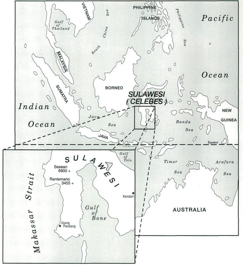
|
| Sulawesi, Indonesia, the destination for plant hunting during May 1997. |
In order to have a reasonable opportunity for good weather, a May trip was decided upon. May is the end of the rainy season; some rains are expected but they should not be as numerous nor as heavy as they are earlier in the season. It was also noted that all of the vireyas found during John's May 1996 trip were in bloom, and although vireyas have no definite flowering season, descriptions in the literature recorded more blooms at this time of year than at any other. Another very basic consideration was that costs are lower in May, prior to the tourist season which starts in June.
Very little information was available concerning the Latimojong Range (Reserve) outside of the general descriptions found in
Ecology of Sulawesi
. Tourists to Sulawesi are normally interested in such things as diving, sightseeing, handicrafts and day treks, so the guide books were of little use. Maps of the area containing routes and place names were either non-existent or were closely held by the Indonesian government. No specific information was available about access to the summit of Rantemario. Attempts to contact mountain climbing organizations proved fruitless. Information from tourist agents was general in nature. By April, we were convinced that arrangements for accessing the mountain range would have to be made after we arrived in Rantepao, a small city in Tana Toraja.
Our explorations would begin near Rantepao with a trek up Mt. Sesean, a mountain which John and Keith had climbed the previous year. Climbing in the Latimojong Mountain Range would follow. We prepared ourselves to search out local villages for guides and porters.
Up to the week prior to leaving for Indonesia, our only information concerning access to Mount Rantemario was that the approach was via two small towns off the highway between Ujung Pandang and Rantepao and that guides and accommodations could be obtained in the nearby towns and villages. Then one week prior to our departure contact was made with a tourist and travel agent in Ujung Pandang, the largest city in Sulawesi. This contact came to John through his communications with various people on the Internet. The agent offered to put together a trip including a guide who was a member of the Indonesia Mountain RescueS.A.R" (search and rescue) organization. This guide had extensive experience in the Latimojong range, knew the route and had climbed Mt. Rantemario several times. He also knew some English, which would be very helpful, considering John's limited knowledge of Indonesian. This plan had possibilities and would save us valuable time in making local arrangements in the mountain towns and villages. Our interest was confirmed by telephone with an agreement to meet the agent and the guide upon our arrival in Ujung Pandang.
We departed Seatac airport at 3:45 a.m. on May 8, 1997, and arrived at Ujung Pandang on Sulawesi at 10 a.m. on May 11 after overnight stops in Taipei, Taiwan and Denpasar, Bali, Indonesia (and a loss of one day when crossing the International Date Line).
A meeting was held withAcho" our guide and the travel agent that afternoon. Acho produced detailed maps of the Latimojong Range and described the route to the summit of Mt. Rantemario. Being satisfied with his knowledge of the area and with his knowledge of English, we finalized plans for a climb of Mt. Rantemario and adjacent Mt. Sinagi, leaving ourselves the option of interrupting the trip if deemed necessary or desirable. Arrangements were also made for a driver and vehicle to take the two of us and Acho to Rantepao the following morning. The temperature was 96° F(35°C).
May 12 was spent driving from Ujung Pandang north along the west coast of Sulawesi into the mountains to Rantepao, elevation 2,440 feet (744 m). After arriving in Rantepao arrangements were made to climb Mt. Sesean the next morning and afternoon and then to purchase food for our climb of Mt. Rantemario. The temperature had cooled off to the mid-80s (30°C).
|
|
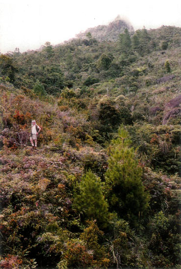
John Farbarik with Mt. Sesean summit in
the background. Plant cover is typical of regrowth after clear cutting. Photo by Hank Helm |
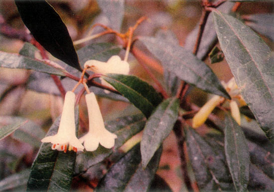
On the morning of May 13, our driver took us to the village of Batumonga (elevation 4,240 feet, 1272m), a small village on the side of Mt. Sesean, where we engaged Mr. Daniel Loto, a local villager, as guide. The trail climbed up through coffee plantations and relatively open grass and brush land to the summit of the mountain. The climb, or rather stroll, to an area just below the summit (5,700 feet, 1710 m) took about one and a half hours. Four species of rhododendron were photographed on Mt. Sesean. The tentatively identified species are: Rhododendron rhodopus , R. zollingeri , R. malayanum and R. quadrasianum var. selebicum . The 8 to 10-foot (2.4-3 m) shrub of R. rhodopus (5,200 to 5,350 feet, 1560-1605 m) had trusses of up to 10 scented large white tubular flowers with widely flaring petals. Rhododendron zollingeri (5,300 to 5,690 feet, 1590-1707 m) was readily identifiable with leaves elliptic-lanceolate having a shortly acuminate apex and with three to eight brick red flowers on 1-1.5 cm pedicels in umbles of three to eight. A carmine colored form of R. malayanum was found on a rock outcropping next to several R. zollingeri at 5,690 feet (1707 m). Rhododendron quadrasianum var. selebicum , a delightful dwarf shrub with inch (1.2 cm) long narrowly-obovate leaves, was not in bloom. Rhododendron rhodopus and R. zollingeri were found along the trail leading to the summit. The R. quadrasianum var. selebicum along with additional R. rhodopus and R. zollingeri was found near a pond where it had been collected by John and Keith Adams in 1996.
|
|
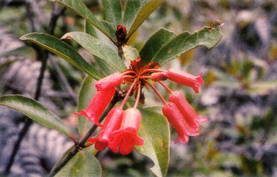
R. zollingeri
. Tall open shrub to 8 feet. Long flower pedicels
with brick red flowers. 5,700 feet on ridge. Mt. Sesean. Photo by Hank Helm |
On May 14 we drove south, on the same highway by which we had arrived, to the town of Cakke (Chake) (elevation 1,640 feet, 500 m). From there we drove east into the foothills of the Latimojong Range. The road became progressively narrow and rough. Approximately two hours of driving from Rantepao brought us to the village of Gura where we were advised by the driver that the vehicle could go no further.
At Gura our guide, Acho, engaged the services of a horse and horse driver to carry our packs the 15 kilometers to Karangan, a village at the base of Rantemario. We proceeded on foot, reaching the end of the rough winding dirt road at the very small village of Buntudeo (4,030 feet, 1209 m), a hike of approximately five miles. The temperature remained in the high 80s (31° C).
The trail into the mountains started at Buntudeo. Our initial view of the trail was frightening. The first hundred yards was very narrow, crossing a steep slope some 300 feet (90 m) above a river. The trail had been nearly obliterated by a huge dirt slide resulting from a large backhoe working on the road above. After crossing the dangerous slide area, the trail widened as it descended into a wide valley. It then passed through farm lands and two villages while climbing steadily for some 4 miles to the village of Karangan (4,780 feet, 1434 m) where we spent the night in a large house.
The trail from Karangan to the summit was not suitable for horses. So early the next morning three young men from the village were hired to act as porters for the trek on up the mountain. The trail from Karangan up the steep slope of Mt. Rantemario climbed through the village coffee plantation, corn and squash fields and two river crossings to a ridge (6,260 feet, 1878 m) above the village. From there it descended through the jungle to a third river crossing at POS 2 (5,980 feet, 1794m), one of seven rest and camp sites along the trail from Karangan to the summit.
The river crossings were an adventure. The first two were bridges constructed of a slippery log with bamboo railing; the railing was attached to the log with thin strips of rattan. The third crossing, at POS 2, consisted of slippery rocks followed by even more slippery logs lying just above the surface of the water.
|
|
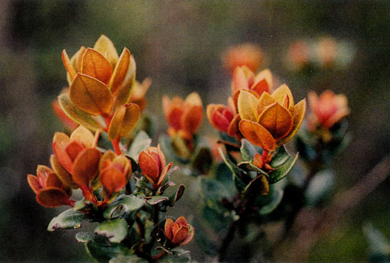
R. lagunculicarpum
? new growth, 8-15 feet tall.
Dominant shrub at 10,000 feet. Mt. Rantemario, Sulawesi, Indonesia. Photo by Hank Helm |
Rhododendron flowers were first seen at POS 2 and then at several more locations on the very steep trail to POS 3. No plants, however, were in evidence and we surmised they were high in the jungle canopy.
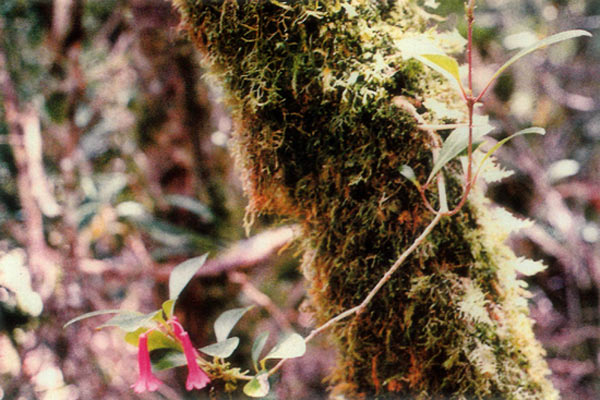
The first rhododendron was found at 6,880 feet (2,097 m). It had medium large leaves and well defined seed pods but no flowers. The second rhododendron was an epiphyte (7,060 feet, 2118 m) which is believed to be
R. celebicum
. Between this elevation and POS 7 (10,480 feet, 3,194 m) where we pitched our tents and set up camp for the night, 12 species of rhododendron were photographed. Among those photographed we have tentatively identified:
R. celebicum
,
R. psilanthum
,
R. radians
,
R. malayanum
(a pink and a pale yellow form),
R. quadrasianum
,
R. rhodopus
,
R. leptobrachion
,
R. paremense
, and
R. lagunculicarpum
. Before the identification of
R. malayanum
, we called itmany scales" for the abundance of rust colored scales on all parts of the new growth and on the underleaf at maturity. The pale yellow form of
R. malayanum
has not previously been described. The
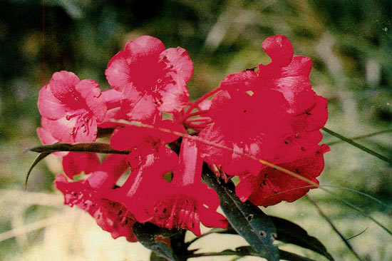
R. leptobrachion
was a very large red flowered plant, some 18 feet (5.4 m) tall, with trusses of 8 to 15 flowers.
Rhododendron lagunculicarpum
, a 15 to 20-foot (6m) tall treelet, became the dominant plant between 9,000 and 10,000 feet (2700 to 3000 m). This is a striking yellow to orange flowered plant with orange-brown ovate new growth covered in scales.
|
|
R. malayanum
(pale yellow form), to 15 feet,
7,900 feet, Mt. Rantemario. Grows in thickets along ridge under taller trees. Photo by Hank Helm |
Among the many plants of R. malayanum at POS 5 a very different plant, as yet unidentified, was found. This plant had few scales on the leaves which were broader than that of the other rhododendrons in proportion to leaf length, and the flower was a darker color. We believe this may be a hybrid as it was a single plant, perhaps R. malayanum with R. leptobracheon (?).
|
|
R. leptobracheon
, dark red flowers, bush 12-15 feet tall.
8,000 feet, terrestrial, Mt. Rantemario. Photo by Hank Helm |
This was a long and difficult day with a climb of 5,700 feet (1,737 m), in sometimes oppressive heat and humidity, over the very steep and rough trail. At many places, especially along the trail just prior to POS 3 and on the trail from POS 2 to POS 3, we had to search for hand holds while climbing over rocks, mud and roots. The excitement, however, of finding so many rhododendrons along with numerous orchids and other plants, and the stops for photographs, helped overcome the fatigue. The weather was clear and the temperature had cooled down to the high 70s (22°C) by the time POS 7 (10,480 feet, 3,194m) was reached. As night approached the camp became engulfed in clouds and mist and a light rain began to fall. The night temperature was in the 45°F to 50°F (10°C) range.
The light rain fell for most of the night, but by morning the weather had cleared. We were able to climb the 800 feet (240 m) to the summit of Rantemario under partly sunny skies. On the way three more species of rhododendrons were photographed. These species were:
R. nanophytum
var.
nanophytum
,
R. pseudobuxifolium
and
R. eymae
.
Rhododendron nanophytum
var.
nanophytum
was the smallest dwarf seen with leaves less than inch (6mm) long and scaly tubular orange red flowers ⅝ inch (1.4 cm) long.
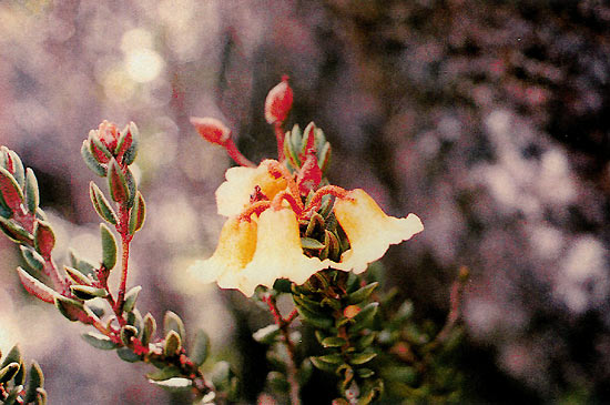
Rhododendron eymae
is a beautiful dwarf with deep yellow funnel shaped flowers in trusses of two to four and with very small ⅜ inch (1 cm) very re-curved heavily scaled leaves. A number of
R. eymae
were found growing out of cracks in the rock which formed most of the summit.
Rhododendron pseudobuxifolium
is remarkable for its scarlet flowers which are large in relation to its ovate leaves.
|
|
R. eymae
, dwarf, less than 1 foot, sulfur yellow flowers,
re-curved leaves. Grows from rock crevices. 10,600 feet, Mt. Rantemaraio. Photo by Hank Helm |
After returning to camp and lunch a traverse was made along the side of the mountain below the summit. On this excursion, what may be
R. quadrasianum
or a variety of
R. nanophytum
was found. We also saw many orchids as well as other alpine flowering plants.
During the night of May 16, the weather turned rather nasty with lightning, thunder, rain and high winds. Because of concern for what would be a treacherous descent and three difficult river crossings and with no assurance that the weather would improve, the decision was made to abort the planned assent of adjacent Mt. Sinagi. We broke camp and began the descent in the rain. We soon found ourselves slipping and sliding down the many steep parts of the trail. Even though it was raining and we wanted to cover as much ground as possible before dark we made several stops when what might benew" rhododendrons were spotted. There wasn't time to cross check all of these with the plants found previously, so we added them to our collection; they would be sorted out later. Of the 12 species which were collected during the descent at least four were found to be different from those found during the ascent to the summit. Three of the species found are tentatively identified as
R. impositum
,
R. lompohense
and
R. bloembergenii
.
We had neither the time nor the energy to make it back to Karangan before dusk so we spent the night at POS 2. The camp site there was on a narrow ledge, only three to five feet wide, some 50 feet (15 m) above the river. A large cliff overhang provided shelter from the rain. Because of concerns about rolling off into the river and in anticipation of making the river crossing the next morning, we were more than a little restless during the night! Staying awake, however, did allow us to see the jungle at night, the fireflies and the bats with the help of the lightning flashes, and to listen to the roar of the river, a roar which muffled the sound of the thunder.
We continued on down to Karangan the next morning, cleaned up some, then proceeded with the porters to Buntudeo where we planned to hire a horse and driver for the final leg to Gura. The walk was through a light rain changing to a heavy downpour as we approached Buntudeo. At Buntudeo, it was necessary to bypass the slide area because the loose soil covering most of the path had turned to mud. The bypass was hand over hand straight up the steep hillside through a coffee plantation and through grass and brush to the top of a ridge and then down a 10 to 12-foot vertical bank to the muddy road. That drop was made by grabbing a conveniently placed coffee tree, swinging out over a muddy ditch, turning 90 degrees, pushing off from the bank and then jumping free for the remaining 5 feet.
The remainder of the walk to Gura was uneventful except for one stream that had overflowed the road and with a couple of stops to douse ourselves under roadside springs to clean off mud from body and boots. By the time we reached Gura the rain had stopped and the sun was shining and the temperature had climbed into the high 80s (36°C) again. At Gura, we caught the last transportation for the day to Cakke and on to Rantepao. It was a public Bemo (heavy duty Toyota station wagon). The ride proved to be interesting as 20 people, on their way to the market at Cakke, were crowded into and onto the vehicle! (Where will we sit? All of the seats are occupied! Don't worry. Don't worry. There is plenty of room.)
After a night of rest in Rantepao, we decided to abandon our plans to climb additional mountains. We had been very successful on Rantemario, had no injuries and had not become ill. Not wanting to press our luck we decided to sightsee for a few days and then to take the next plane home. The return to Ujung Pandang the next day was via Palopo, down along the Bay of Bone, across to Parapara and then back south to Ujung Pandang where we arrived that evening. After wrapping up our affairs the next morning we caught a plane to Bali where we spent two days in the town of Ubud visiting the market, a silversmith, mask maker, wood carving shop and artists gallery and attending a Hindu religious ceremony. We departed Denpasar on May 23 and after an overnight stop in Kaoshiung and an 11-hour flight from Taipei arrived in Seattle on May 24.
Distribution of Vireyas
Sleumer, in his introduction to
Flora Malesiana
(Ericaceae), notes that Malesian Ericaceae are found most abundant as epiphytes in the forest and terrestrially on steep slopes, ridge-crests, glades and other sterile places and are not rarely found in open or fired places and on rock walls. Most of the vireyas found on Gunung (Mt.) Rantemario were found near the trail along a relatively sharp ridge line between POS 3 and POS 7. The remainder, with the exception of R 1 and R 2 (
celebicum
) were found on rocky sterile slopes and near the summit, which, according to
The Ecology of Sulawesi
had been burned in relatively recent times. Both R 1 and the epiphytic R 2 (
R. celebicum
) were found in relatively heavily wooded lower montane forest.
|
|
R. celebicum
, epiphytic, roots tuber-like. 7,000 feet, Mt. Rantemario.
Photo by Hank Helm |
The four species found on Gunung (Mt.) Sesean were found on open brushy slopes. The epiphytic
R. celebicum
found in 1996 on Gunung Klabat in north Sulawesi was found along a trail running up a sharp ridge line.
It must be noted that all of the vireyas found, both in 1996 and 1997, were along established trails. These were undoubtedly the very same trails used by earlier collectors. The conclusion must be drawn that there are more vireyas to be found on Klabat, Sesean and particularly on Rantemario. The steep eastern side of Rantemario and the remainder of the Latimojong Range and the east side of Klabat which is still heavily forested must be considered to beunexplored" and, because of their relative inaccessibility, will probably remain so.
Guides and Porters
There is no substitute for a good guide if one is to climb any of the mountains in Indonesia. Although we had at first considered hiking without a guide or finding guides in the villages near Mt. Rantemario, we were convinced, prior to the start of our trip to Indonesia, that one was necessary.
The guide for the one day Gunung Sesean excursion, Daniel Loto, lives in Batumonga, right at the start of the trail to the summit. He assisted us in finding the trail out of the village and up the mountain and in locating a site which John had visited on his previous trip in 1996.
The guide who led and assisted us in our climb of Rantemario was invaluable. He (Acho), a member of the Indonesian Mountain Rescue team, instructed our driver in getting to the most convenient jumping off point and in picking us up at the end of our climb, arranged for a horse to carry our baggage, arranged for porters, negotiated prices, led us up and down the mountain, cooked for us, interpreted as necessary, helped us cross streams, obtained a substitute automobile and driver when our schedule changed, and helped us in understanding the local ecology and environment.
Contacting and negotiating prices directly with individual guides is much less expensive that going through a tourist agency, but the coordination provided by the agency may very well be worth the additional cost, especially for the inexperienced Indonesia traveler.
Environment / Ecology
We saw very few animals either in the foothills and valleys leading to Rantemario or on Rantemario itself, only a few birds, a couple of large millipedes, and one 1.5 meter long black snake. We saw the droppings of what was, according to our guide, an anoa, a dwarf sized buffalo endemic to Sulawesi, and saw where a number of animals, probably wild boar, were rooting alongside the stream near the summit. It is understood that many of the jungle animals are nocturnal, but we should have seen more than we did. It must be assumed that the animals are being killed or captured or are dying off because of diminishing habitat.
It is obvious that the ecology of Sulawesi is deteriorating very rapidly. Villagers are cutting rattan in the reserve and slowly but surely cutting the forest trees, even those in the reserve, for firewood. Once the trees have been removed, the remaining brush is burned and the land is cleared. In the area around Rantemario the steep newly cleared land is being planted with coffee and corn. Rice fields are being planted on 1.25:1 slopes. Roads are being built into areas which were, just a few years ago, forests. Farms are slowly creeping up the mountain sides into the reserve. They are at the 5,000 to 6,000-foot (1500-1800 m) level now and climbing on Rantemario. On Sesean farm buildings are being constructed and coffee is being planted within 500 meters of the summit. Most of the small animals have been killed. (One of our drivers told us that he always carried an air rifle in case he had a chance to shoot an egret or some other bird. Our porters discussed the possibility of trapping or shooting an anoa - how good it would taste!) Garbage is piling up along the trails and campsites. Mangrove swamps are being converted to fish and shrimp farms. (An example is the Bay of Bone east of the road just south of Palopo.) The soil is being washed away as a result of extremely poor farming and construction practices. The streams and rivers run muddy to the sea.
We would like to express our thanks and appreciation to the following: Mr. FandaAcho" for his assistance in many ways as our guide; Mr. Michael Papayungan and Mr. Joe Erwin for their valuable advice during the early stages of our planning; Mr. Harun Azlkin for making arrangements for the trek; Mr. Steve Hootman, Curator, Rhododendron Species Foundation, for classification assistance; and the people of Sulawesi for their hospitality.
Notes on our trek up Mt. Sesean and Mt. Rantemario in abbreviated tabular form and information on guides, tourist agents and accommodations are available from Mr. Henry Helm and Mr. John Farbarik over the Internet. The notes contain a listing of tentatively identified species, along with the latitude and longitude of key locations and plant elevations. Latitude and longitude readings were obtained by use of GPS receivers. Altitudes were read with the GPS receivers and with differential barometric pressure altimeters. Herbarium specimens of all plants are being prepared at the Rhododendron Species Foundation. Slides of the approximately 20 rhododendrons photographed have been given to the Rhododendron Species Foundation. The material collected should aid our understanding of several rhododendron species as well as adding to the body of vireya data. The trip could not have been more successful as far as we were concerned.
| Table 1. Rhododendrons Observed on Sulawesi Expedition, May 1997. | |||||
| Location | Comments | Date 5/ | South Lat. | East Lon. | Elev. (ft./mtrs.) |
| Cakke | Road lntersection | 12 | 3° 24' 30.2" | 119° 48' 03.8" | 1640/500 |
| Rantepao | Wisma Monton | 12 | 2° 58' 00.8" | 119° 54' 08.6" | 2440/744 |
| Batumonga | Start of Sesean Trail near school | 13 | 2° 54' 55.8" | 119° 52' 45.6" | 4240/1292 |
| Sesean 1st | R. rhodopus ? | 13 | 2° 54' 19.2" | 119° 52' 39.2" | 5350/1631 |
| Sesean 2nd | R. rhodopus ? | 13 | 2° 54' 09.7" | 119° 52' 43.0" | |
| Sesean 3rd | R. malayanum ? | 13 | 2° 54' 09.1" | 119° 52' 44.0" | 5690/1734 |
| Sesean 4th | R. zollingeri ? | 13 | 2° 54' 09.1" | 119° 52' 44.0" | 5630/1716 |
| Sesean/ Near Summit | 13 | 2° 53' 58.2" | 119° 52'4 0.6" | ||
| Sesean-96/97 collection |
R. rhodopus
?
R. quadrasianum var. selebicum ? |
13 | 2° 54' 15.2" | 119° 52' 35.2" | 5530/1686 |
| Baraka | Road @ town | 14 | 3° 24' 14.6" | 119° 51' 00.0" | 1390/424 |
| Gura | Start w/horse | 14 | 3° 25' 35.9" | 119° 54' 33.0" | 3070/936 |
| Gura | End walk/Bemo | 18 | 3° 25' 38.0" | 119° 54' 14.0" | 2860/872 |
| Buntudeo | Road end/Trail start | 14 | 3° 26' 02.0" | 119° 57' 40.0" | 4030/1228 |
| Rantelemo | School | 14 | 3° 26' 03.6" | 119° 58' 08.5" | 3850/1173 |
| Karangan | Overnight/Porters | 14 | 3° 25' 09.8" | 119° 59' 19.3" | 4780/1457 |
| POS 1 | Starting up Mt. | 15 | 3° 24' 51.8" | 119° 59' 53.5" | 5750/1753 |
| POS 1/POS 2 | High Pt./prior descent to POS 2 | 15 | 6260/1908 | ||
| POS 2 | River crossing/Steep trail beginning | 15 | 5980/1823 | ||
| POS 3 | 15 | 3° 24' 27.5" | 120° 00' 28.9" | 6670/2033 | |
| R1 | R ? | 15 | 6880/2097 | ||
| R2 | R. celebicum ? | 15 | 7060/2152 | ||
| R3 | R. psilanthum ? | 15 | 7170/2185 | ||
| POS 4 | 15 | 3° 24' 17.8" | 120° 00' 43.7" | 7470/2277 | |
| R4 | R. radians ? | 15 | 7880/2402 | ||
| R5 | R. malayanum (pink) ? | 15 | 7880/2402 | ||
| R6 | R. quadrasianum ? | 15 | 7930/2417 | ||
| R7 | R. malayanum (pale yellow) ? | 15 | 8620/2627 | ||
| POS 5 | 15 | 3° 24' 24.6" | 120° 01 ' 39.5" | 8620/2627 | |
| R8 | R. rhodopus ? | 15 | 8620/2627 | ||
| R9 | R. lepfobracheon (large red) ? | 15 | 8780/2676 | ||
| R10 | R. ? | 15 | 8970/2734 | ||
| R11 | R. lagunculicarpum ? | 15 | 9310/2838 | ||
| POS 6 | 15 | 9560/2914 | |||
| R12 | R. ? | 15 | |||
| POS 7 | Camp Site | 15 | 3° 23' 40.5" | 120° 01' 39.5" | 10480/3194 |
| POS 7 Ridge | Ridge prior to POS7 | 16 | 3° 23' 33.0" | 120° 01' 33.4" | 10560/3218 |
| R13 | R. eymae ? | 16 | 3° 23' 39.0" | 120° 01' 44.5" | 10640/3243 |
| R14 | R. pseudobuxifolium ? | 16 | 11130/3392 | ||
| Summit | Summit of Rantemario | 16 | 3° 23' 05.7" | 120° 01' 26.7" | 11280/3438 |
| R15 | R. nanophytum ? var. nanophytum ? | 16 | 11130/3392 | ||
| R15a | R. quadrasianum or R. nanophytum ? | 16 | 11130/3392 | ||
| A | R. paremense ? | 17 | 10100/3078 | ||
| B | R. ? | 17 | 10080/3072 | ||
| C | R. ? | 17 | 10000/3048 | ||
| D | R. ? | 17 | 9960/3036 | ||
| E | R. impositum ? | 17 | |||
| F | R. lompohense ? | 17 | 9100/2774 | ||
| G | R. ? | 17 | 8810/2685 | ||
| H | R. ? | 17 | 8700/2652 | ||
| I | R. ? | 17 | 8620/2677 | ||
| J | R. ? | 17 | 8620/2677 | ||
| K | R. ? | 17 | 7910/2411 | ||
| L | R. celebicum ? | 17 | 7530/2295 | ||
Hank Helm and John Farbarik Are members of the Kitsap Chapter.