JARS v56n1 - Western North American Species Project
Western North American Species Project
Mapping
Rhododendron macrophyllum
on Whidbey and Cypress Islands, Washington State
Clarice
Clark
Puyallup, Washington
Synopsis:
An effort to update the distribution map of
Rhododendron macrophyllum
on Whidbey and Cypress Islands
with GPS devices through inquiries to local residents and state and federal agencies. Volunteers gathered new
information about locations of native rhododendrons and incorporated the data into a computerized geographic
information system. Maps that accompany the article show the current distribution of
Rhododendron
macrophyllum
occurs primarily on public lands, with little remaining on private property.
The Western North American Rhododendron Species Project (or WNARSP) members are continuing in their attempts to collect and organize information about the natural distribution of some of our native rhododendrons. In 1999 and 2000, the efforts of the core members were focused on Whidbey Island and Cypress Island, both located in Washington State (see map, Fig. 2).

|
Whidbey Island
Why Whidbey? It is an island very close to a large metropolitan area, yet still somewhat rural, with a
reputation for its
Rhododendron macrophyllum
. The local chamber of commerce proudly features the
native rhododendron as being "abundant throughout much of the island" and easy to see from the road on
driving tours. Whidbey is also the home of the Meerkerk Rhododendron Gardens a well-known garden established
to test hybrid rhododendrons, and the manager there, Kristi O'Donnell, is one of our sources for information.
She was the first person we turned to when logging and land clearing activity near a popular park caused
concern among the Project members.
|
|
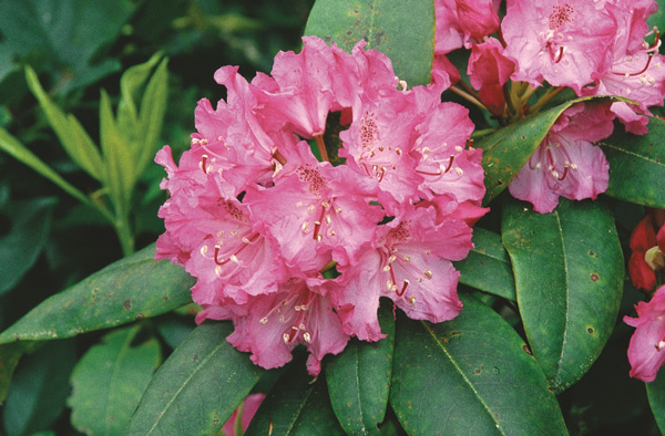
R. macrophyllum
with red truss, Whidbey Island, Washington.
Photo by Hank Helm |
Rhododendron Park is located near the center of Whidbey Island, on the main highway and close to the county seat, Coupeville. Since it is land that belongs to the Department of Natural Resources and not a state park, it is subject to logging in order to produce funds for schools and other state operations. When logging activity was observed in June of 1998, project members were concerned about the status of the rhododendron - would the area be burned and replanted? Precise mapping with handheld Global Positioning System (GPS) receivers revealed that the park itself was not involved, but private landowners on each side of a narrow entrance road harvested the marketable timber on their property and then left the sites to regenerate.
One of the goals of the WNARSP is to document, whenever possible, not only spatial information such as location and elevation, but land ownership. In most cases, we can identify the parcel as being owned by a state, federal or non-profit organization, or is in private hands. This information can help both now and in the future. Presently, it tells Project members something about right of entry and whom to contact for information or permission. For future needs, we hope to be able to provide baseline information for the status of our beloved plants, which at the present time are not endangered, but with increasing urbanization and changing weather patterns, may become more or less plentiful.
Discussions with local Whidbey residents triggered an alert about another area of "Rhodies in Peril" - a narrow stretch of State Highway 20 slated for widening. Could we assist with efforts to defend the Rhododendron macrophyllum plants that form a picturesque hedge alongside the road? We took this request back to a committee meeting for review, and discussions turned into a plan to survey the occurrence of R. macrophyllum on the entire island and see if this one area deserved special consideration and protection.
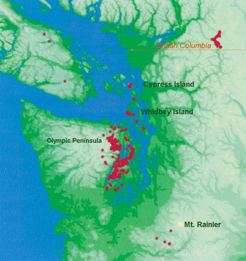
Effort began in early 1999 by contacting the Department of Natural Resources (DNR) Natural Heritage Program. This program is designed to identify and protect, if necessary, Washington State native plants and animals. Vegetation ecologists were able to provide latitude and longitude from survey plots that we could use to identify areas of rhododendrons. Along with a list of locations on Whidbey Island came a short note: "Other areas…no specific location data available: South side of Cypress Island, Skagit Co." This was intriguing information, because Cypress Island was approximately 10 miles north of the north end of Whidbey Island, and the end of Rhododendron macrophyllum in Washington State, until it re-appears on Vancouver Island, British Columbia (see map, Fig 1). It seemed natural to investigate the two islands as the rhododendrons may be related, but the undertaking would involve more complicated logistics - there was no ferry or bridge connection to Cypress Island.
|
|
Figure 1. Relative locations of Whidbey and Cypress Island in the Pacific Northwest
with known populations of R. macrophyllum shown in dark pink. Map by Clarice Clark |
Our next step was to enlist a local resident who is active in the ARS chapter on Whidbey Island, Bill Stipe, owner of Glynneden Gardens near Greenbank. We needed a traveling companion who was familiar with the island to guide us on our field trip to map any rhododendrons on private land. We joined forces May 22, when the Rhododendron macrophyllum would be in bloom. Bill was able to arrange access to a parcel of undeveloped private land near Lone Lake, and we found approximately 5 acres of R. macrophyllum . Rick Peterson and Richie Steffen of the Rhododendron Species Foundation collected seed and distributed it to members. There is a large parcel of DNR land very nearby, known as the Metcalf Trust Keller Park, which we thought might have rhododendrons. (Subsequent interviews with DNR employees and neighbors lead us to believe there is no R. macrophyllum on this site, but we did find a few more plants on nearby private land when we returned the following year.)
Returning to the highway, we viewed a bog full of Rhododendron groenlandicum (formerly Ledum), drove north to the "Rhodies in Peril" area near Lake Hancock and admired the overhanging display of pink flowers on the road bank. The area to the west of the road is US Navy property, which was a target range before and during WWII for pilots at NAS Whidbey. Initial estimates of the property were limited to scouting along the road and along the fences, but subsequent visits, conducted with the permission of the Office of Environmental Affairs, enabled us to estimate that of the 400 acres the Navy owns, about 80 acres is suitable upland habitat. Further investigations along adjacent private land to the north and east revealed some dark color forms and further defined the extents of the population. There are few or no rhododendrons north of the Navy property, and approximately half, or 40 acres, of the Navy property is second growth Douglas fir with rhododendrons as understory. Although the Navy has deeded over additional right of way for the highway widening, there will be a substantial population of plants left on site after the project. The Navy is unlikely to sell or develop this property, as there are still concerns about unexploded ordnance.
|
|
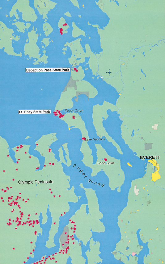
Figure 2. Whidbey Island, WNARSP data collected
with GPS receivers shown in dark pink. Map by Clarice Clark |
It is unlikely that attempts to move large plants - many of which are 12 to 15 feet (3.6-4.5 m) tall - will be satisfactory. Rhododendron macrophyllum has shallow roots that depend on good aeration, and it has been the experience of every member of the WNARSP that mature plants do not transplant well. We have all witnessed firsthand the demise of plants dug from the wild and moved to a nursery or home environment. Growing plants from seed would produce large numbers of small plants that could be planted during our wet season and have the greatest chance of survival. (It is understandable that island residents fear the loss of their roadside beauty. Before being protected by state law in 1961 1 , R. macrophyllum was collected in the wild, balled and burlapped for sale, often by the truckload. 2 )
The next segment of this trip focused on the information supplied by the DNR for two sites at the north end of Whidbey Island. By loading the latitude and longitude of the destination into the GPS receiver, we were able to use the device for precise directions and find the rhododendrons quickly. The Goose Rock group campsite at Deception Pass State Park is a heavily used area and the Rhododendron macrophyllum was limited to approximately 3 acres on a remote slope under heavy overstory. Less than a mile away, on a DNR trust site rarely visited by the general public, we found almost 8 acres of R. macrophyllum . A search of the neighborhood failed to find any rhododendrons on private land between the two sites.
The next bloom season found project members back on Whidbey the 20th of May. A scouting visit to Ft. Ebey State Park brought to light the need for mapping large areas spread over several square miles. Within the park, we found Rhododendron macrophyllum and R. groenlandicum growing together in a seasonal marsh that drains from Lake Pondilla. While looking for an isolated piece of the park, we entered an area of private land on a new gravel road leading into a freshly created subdivision. We hope to monitor the survival rate of the plants as houses are built and lawns and gardens are put in. Our sturdy Pacific Northwest native resents fertilizers and rarely survives overhead watering in the summer, making it a poor candidate for most homeowners' yards. In fact, the US Forest Service uses R. macrophyllum as an indicator plant - it is dominant in soils with low levels of available nitrogen. 3 A map obtained by the Central Whidbey Trails Council revealed that the Kettles trail (paved) visible from Highway 20 was linked to a network of public access trails for hiker, horseback riders and mountain bikers. This tract, part of the Ebey's Landing National Historic Reserve, proved to be permeated with Rhododendron macrophyllum . The reserve is a 22-square-mile area of historic sites established by the National Park Service and bodes well for the protection of the native plants. There is also R. macrophyllum scattered thinly on private land to the east of the park, around Penn Cove in an area known as Coveland. We have been unable to find any rhododendrons between Coveland and the Deception Pass State Park, a gap of some 12 miles.
Our research creates a map of Whidbey Island with rhododendrons densely clustered in the center of the island (a non-contiguous total of approximately 1200 acres) with a few acres on state land at the north end, and the plants at Lone Lake, near the south end. Is human land use the deciding factor in whether or not rhododendrons survive, or are there other factors? Central Whidbey Island falls in the Olympic Mountain rain shadow, producing a yearly rainfall of only 16-20 inches (40-50 cm), compared with an average of 30 inches (75 cm) on the north and south parts of the Island. The fact that the rhododendrons thrive on the drier parts of the island is unusual for this plant, which usually prefers high soil moisture.
|
|
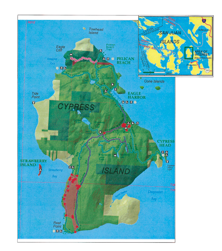
Figure 3. Detail of Cypress Island. Base map courtesy of Washington State DNR with
locations of R. macrophyllum mapped by WNARSP shown by overlay of dark pink. Map by Clarice Clark |
Cypress Island
We pressed on to Cypress Island, to gather more information. About 4,700 acres on the island are protected
as a Natural Resources Conservation area. Of this acreage, almost one quarter is managed as a Natural Area
Preserve, the highest level of protection for Washington's natural heritage, including a rare low-elevation
serpentine forest. Thanks to the powerboat operated by the Cypress Island Steward, Kathy Gunther, we were
able to cross the 5 miles from Anacortes with relative ease. As we sped along, I recalled a clipping Kathy
had sent me, from the local newspaper, dated May 25, 1916: "The rhododendron, the beautiful state flower of
Washington, is now blooming on Cypress Island and many lovers of the out of doors are visiting
the delightful retreat these days as the result."
4
It would have been a long paddle to Eagle Harbor, and a preview of the topography of the island with computer software had alerted me to the fact that we faced some steep terrain and a 7-mile hike. Luckily, Kathy was also able to provide motorized transport for five committee members, and our guests, ARS President Lynn Watts and three of his family who had joined us from nearby Guemes Island. Kathy furnished maps of the island and guided us to two sections where rhododendrons were on state owned land. At Reed Lake, a previous attempt at a development left a shallow lake and a road leading to an airfield. Our party eyed this group of plants (perhaps 8 acres) with suspicion: could rhododendrons have been planted here as an attempt to enhance the lakeside? There had even been plans to change the name of the island to Rhododendron Island - more evidence of a promoter's efforts to entice patrons to the island retreat? Or was the retreat planned around existing plants?
We proceeded down the Mainline road, also known as Foss Road, the name of previous private owners, who logged the area before selling to the DNR. Here we began to see rhododendrons in a more natural setting, and lots of them. We took GPS readings along the road, plunging into the underbrush at regular intervals and then proceeded on foot to map along the trail where a van could not go. Although the last hour was in a "heavy mist," our spirits were high as we were picked up by boat and ferried back to Anacortes after a long day. Mapping our readings gives us a rough estimate of 170 acres of rhododendron on the south half of the island, much of which are serpentine soils on west-facing slopes (see map Fig. 3).
Along the way, we took photographs and compared the flowers. We found little diversity in terms of floral characteristics like color, spotting and size. Is such small variation in morphology indicative of closely related plants, or of plants that have recently colonized a site? The Cypress plants could all be descended from a small number of founder plants or seed.
Plant Origins
WNARSP members have been working with researchers from the University of Washington who are exploring
biodiversity in our native
Rhododendron macrophyllum
. They are collecting leaves and extracting
DNA and comparing sequences of the same gene. The results give them a broad picture of the types of DNA in
various populations, and research is continuing to collect more data. WNARSP members will assist in this
joint project to test the hypothesis that plants thriving today in the Hood Canal region have descended
from a very small number of
R. macrophyllum
that survived the last ice sheet to cover the Puget
Sound about 12,000 years ago. These plants were growing at elevations in the mountains on the Olympic
Peninsula that were high enough to escape the glaciers, in what is known as a "refugia." As the ice
retreated, the plants spread out over parts of their former range. We may never know if the plants on
Cypress Island were imported by humans or re-populated the island by natural means. One day we may be able
to find out if they are related to any of their Puget Sound neighbors, or if the source of the plants is a
population in Oregon hundreds of miles away. At the Fifth International Rhododendron Species Symposium
held in Bellevue, Washington, in April 1999, Dr. Amy Denton gave a very interesting presentation about
DNA studies of
Ericaceae
. In her talk, she touched briefly on the findings that the rhododendrons
on Vancouver Island, British Columbia, do not appear to be related to their nearest neighbors, but have a
closer relationship to plants studied in the Siskiyou Mountains in Central Oregon.
We would love to find more rhododendrons, as we have no confirmed reports from any of the other San Juan Islands or the mainland between Mt. Rainier and the Skagit Valley population in British Columbia. It would be very valuable to document and collect samples for DNA analysis from any remnants in those areas. Current plans for field trips will concentrate on the Hood Canal in 2001, in conjunction with University of Washington students and the DNR Natural Heritage Program.
We urge readers to contact the Project with observations, suggestions for future field trips, or requests for a speaker for your group.
For further reading, see "Mapping Rhododendron macrophyllum in the Wind River Area of Washington State" by Clarice Clark, JARS 53:2.
Acknowledgements
The members of the WNARSP would like to thank the Research Foundation of the American Rhododendron Society
for a grant to pursue research mapping and the development of outreach program materials.
Footnotes:
1
Revised Code of Washington, 47.40.080.
2
Kruckeberg, Arthur R., 1982, Gardening with Native Plants of the Pacific Northwest,
Seattle: University of
Washington Press, p. 89.
3
http://www.fs.fed.us/database/feis/plants/tree/rhomac.html
4
The Anacortes American, May 25, 1916, p. 4.